Within Dorset UFOs
Why Dorset Skies Produce UFO Reports
Dorset's sea views, airport history and aviation traffic can make ordinary lights look strange from the ground.
On this page
- Coastal viewpoints and distance illusions
- Bournemouth Airport and RAF Hurn history
- Aircraft, satellites, meteors, drones and other checks
Page outline Jump by section
Introduction
Dorset skies produce UFO reports partly because the county is a good place to misread distance, height and speed. From clifftops, beaches and harbours, a light may be an aircraft crossing the Channel, a vessel on the horizon, a lantern drifting inland, a drone close by, a meteor, a satellite train, or military activity near the coast. That does not make every report worthless. It does mean the first question is often not “what exotic object was seen?” but “what ordinary sky traffic could look strange from this exact viewpoint?” Dorset’s official record supports that cautious approach: the Ministry of Defence logged local reports from Bournemouth, Christchurch, Sopley, Wareham, Poole and Bridport, but most entries are brief descriptions rather than investigated case files. [GOV.UK Assets+2GOV.UK Assets]assets.publishing.service.gov.ukUK AssetsUK Assets
This page uses Dorset as the working county frame while noting one boundary complication. Bournemouth and Christchurch are now routinely treated as part of Dorset in modern policing and local government contexts, but Dorset Council’s own historic maps guidance notes that they were part of Hampshire until 1974. The project’s historic-county map frame therefore needs a light touch here: the sky factors are real for the modern south-east Dorset conurbation, but older county labels may not always align with present-day Dorset usage. [Dorset Council]dorsetcouncil.gov.ukOpen source on dorsetcouncil.gov.uk.
Coastal viewpoints make lights look stranger than they are
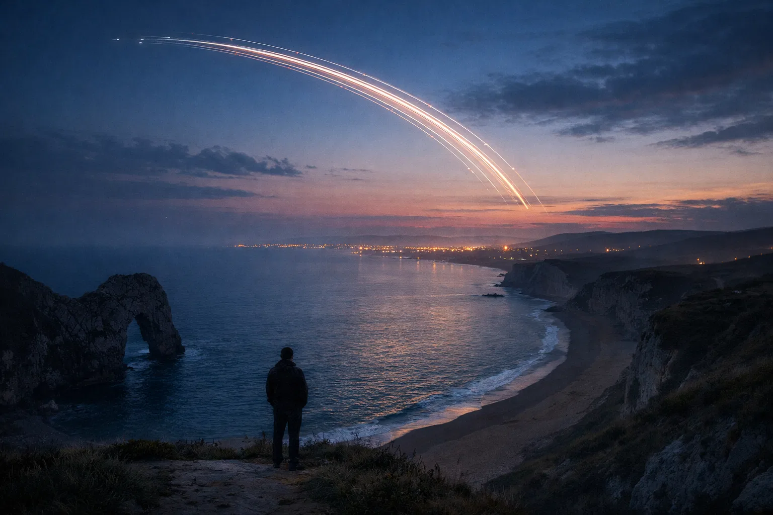
Dorset’s coast gives witnesses long sightlines over dark water. That is excellent for noticing unusual lights, but poor for judging what those lights are. A point of light above the Channel may have no visible ground reference, no obvious sound, and no easy clue to whether it is a nearby drone, a low aircraft, a distant ship, a lighthouse, a flare, or a bright astronomical object. From places such as Portland, Weymouth, Poole, Swanage, West Bay or the Purbeck coast, the witness may also be looking across busy sea lanes and aviation routes rather than into an empty sky.
The Portland Bill example shows why this matters. Trinity House describes Portland Bill Lighthouse as a navigation light for vessels heading for Portland and Weymouth and as a waymark for ships navigating the English Channel; the present light has an 18 nautical mile range and a flashing character of four flashes every 20 seconds. A fixed, repeating maritime light should not be mistaken for a manoeuvring craft by someone who knows the coast, but a visitor seeing it through haze, cloud gaps or from an unfamiliar angle may report flashes, pulsing, disappearance and reappearance. [Trinity House]trinityhouse.co.ukportland bill lighthouseportland bill lighthouse
The coast also encourages distance illusions. A light moving horizontally near the horizon can appear to climb or descend if the observer is on a sloping beach, turning their head, or watching through broken cloud. A ship’s lights can seem suspended above the sea if the horizon is invisible. An aircraft approaching head-on may look stationary for several minutes, then suddenly “accelerate” sideways when it turns or crosses the observer’s line of sight. These are not excuses to dismiss witnesses; they are the basic geometry that any Dorset sky report has to survive.
Weather can sharpen the effect. The Met Office explains that a temperature inversion occurs when temperature increases with height, trapping cooler air near the surface under warmer air. In marine settings, layered air can bend light and produce superior mirages, where distant objects appear higher than their true position. SKYbrary, an aviation safety reference, describes a superior mirage as occurring when light rays are bent down through a temperature inversion, making an image appear above the real object. [Met Office]weather.metoffice.gov.ukOpen source on metoffice.gov.uk.
That is especially relevant to Dorset because many reports are of lights rather than structured objects. A coastal witness may honestly describe a “hovering” or “silent” object when the evidence is actually a bright point seen without reliable scale. The report may still be unexplained in the narrow sense, but it is not automatically strong evidence of an extraordinary craft.

Bournemouth Airport and RAF Hurn add real aviation texture
Bournemouth Airport is one of the main reasons Dorset UFO reports should be checked against aviation activity before anything more speculative is considered. The airport sits at Hurn, near Christchurch, and its own RAF centenary history says the site opened as RAF Hurn in 1941. During the Second World War it was used by the RAF and the United States Army Air Forces as a transport and fighter airfield, supported D-Day operations, and was associated with airborne radar development. [Bournemouth Airport]bournemouthairport.comOpen source on bournemouthairport.com.
That history matters because “military skies” in Dorset are not a UFO myth imposed from outside. The county has had real airfields, training, defence activity and technical aviation work. The Airfields of Britain Conservation Trust lists Hurn, also known as Bournemouth Airport and RAF Hurn, as opened in July 1941, used by the RAF, RCAF, USAAF and civil operators, and still active in aviation use. [Airfields of Britain Conservation Trust]abct.org.ukAirfields of Britain Conservation Trust Hurn (BournemouthAirfields of Britain Conservation Trust Hurn (Bournemouth
The official UFO logs show why Hurn and Bournemouth are relevant to interpretation. On 4 January 1999, the MoD table recorded a Bournemouth report at 06:45 of “one disc shaped object” with “two bright, blue flashing lights”. Those details are intriguing at first glance, but they are also exactly the kind of description that needs checking against aircraft lighting, airport operations, emergency services, early-morning visibility and the witness’s location relative to Hurn. The MoD table gives no investigation narrative, no radar result, no weather check and no witness interview, so the entry is a prompt for analysis, not a solved case. [GOV.UK Assets]assets.publishing.service.gov.ukUK AssetsUK Assets
The same applies to later Christchurch-area reports. In July 2008, the MoD logged a Christchurch report of a “large, silver metallic disc”, seen more than two weeks before the message was taken. In October 2008, Sopley/Christchurch produced a much more dramatic-sounding entry: “one hundred possible UFOs in the sky” at 19:55. Sopley lies close to the Hurn/Christchurch aviation landscape, but the MoD table itself gives too little information to say whether the objects were aircraft, lanterns, birds, balloons, military activity, satellites or something else. [GOV.UK Assets]assets.publishing.service.gov.ukUK AssetsUK Assets
This is the central lesson for Dorset: proximity to an airport does not debunk a sighting by itself, but it raises the standard of checking. A reliable local assessment would ask for the direction faced, duration, angular height, sound, colour pattern, weather, date certainty, nearby events, aircraft movements, and whether multiple independent witnesses saw the same thing from different places.
Military activity around Dorset complicates the night sky
Dorset’s military geography is not only about Hurn. The Lulworth Ranges sit on the Purbeck coast, and the Ministry of Defence publishes firing notices warning people not to enter the danger area when the range is in use. The Dorset Coast Forum notes that Lulworth Outer and its Air Danger Area is shared with the Royal Navy for live-fire activity. [GOV.UK]GOV.UKLulworth firing timesLulworth firing times
This does not mean that every strange light near Purbeck, Wareham or Weymouth is military. It means that lights in this part of Dorset may have more prosaic defence-related possibilities than a casual observer realises: range activity, vessels offshore, aircraft on exercises, illumination, flares, helicopters, or lights connected with safety and exclusion zones. The Defence Infrastructure Organisation’s history of Lulworth says the area has been associated with tank and gunnery training since the First World War, when Bovington and Lulworth were selected as key locations for Britain’s early tank training. [Inside DIO]insidedio.blog.gov.ukInside DIO100 Years of Firing At Lulworth Training AreaInside DIO100 Years of Firing At Lulworth Training Area
The Wareham-area MoD entry from November 2008 shows the problem with thin records. It simply records East Stoke/Wareham at 20:18 as “a pretty unusual sighting”. That phrase is attention-grabbing, but it contains almost no evidential content. Without direction, height, movement, duration, number of witnesses or any check against military and aviation activity, it cannot be ranked with better documented cases. [GOV.UK Assets]assets.publishing.service.gov.ukUK AssetsUK Assets
The same caution applies to Poole, logged later that month only as “a UFO flew across the sky”. Poole Harbour, the Purbeck coast, Bournemouth Airport approaches and wider Solent aviation traffic all sit within the broader viewing environment, but the entry itself is too sparse to identify a cause. It is useful as a data point showing that reports were made; it is weak as evidence for an unusual object. [GOV.UK Assets]assets.publishing.service.gov.ukUK AssetsUK Assets

Orange lights: the Dorset pattern that fits a national wave
The most recognisable Dorset sky-report pattern is the orange-light sighting. The Bridport entry of 25 June 2009 is a good example: the MoD log says three orange lights were seen south of Bridport, coming from the east, moving west, and rapidly diminishing. That description is not enough to prove Chinese lanterns, aircraft, flares or any single explanation, but it fits a wider 2008–09 UK pattern in which orange lights were repeatedly reported as silent, slow, grouped, fading or moving in formation. [GOV.UK Assets]assets.publishing.service.gov.ukufo report 2009ufo report 2009
The National Archives’ release material for the final MoD UFO files says the UFO desk handled its final two years from late 2007 to November 2009 and that reports trebled in its last year. It also says the MoD concluded the work served no defence purpose and encouraged correspondence; the same release states that in more than 50 years no UFO report to the MoD had revealed anything suggesting an extraterrestrial presence or military threat to the UK. [National Archives]cdn.nationalarchives.gov.ukNational Archives
A separate National Archives transcript gives the practical reason many late reports are treated cautiously: the “vast majority” of sightings in 2008 and 2009 appeared to be down-to-earth objects such as Chinese lanterns released at parties and weddings. That does not settle the Bridport report automatically, because a table entry is too brief to prove the cause, but it places Dorset’s orange lights inside a known national reporting wave rather than an isolated county mystery. [National Archives]cdn.nationalarchives.gov.ukufo video transcriptufo video transcript
This is where sceptical interpretation is strongest. Multiple orange lights, no engine noise, slow drift, fading out and group movement are all features that can sound extraordinary to a witness while still fitting lanterns or other wind-borne lights. The strongest unresolved cases would need features that break that pattern: sharp turns against the wind, verified high speed, radar correlation, close-range structure, or independent sightings from separated locations.
Aircraft, satellites, meteors and drones: the checks that matter now
Modern Dorset sightings need a wider checklist than older MoD reports had. Aircraft remain the first check near Bournemouth, Poole, Christchurch and the coast. A plane at distance may show landing lights without obvious navigation lights, and a helicopter may appear to hover. Aircraft noise can be absent or delayed because of wind direction, terrain, surf noise, urban background sound or simple distance.
Satellites are another common source of confusion. Starlink in particular has changed the public sky. Space.com explains that Starlink satellites are visible when they reflect sunlight rather than because they carry their own lights, and freshly deployed groups can appear as a train of bright points crossing the sky. A witness expecting single satellites may therefore report “a line” or “fleet” of objects. [Space]space.comStarlink satellite train: how to see and track it in the night skyStarlink satellite train: how to see and track it in the night sky
Meteors create a different kind of report: a brief, bright streak or fireball, sometimes with colour, fragmentation or an apparent change in direction. They are usually seconds-long events, so Dorset reports lasting several minutes should be checked against aircraft, drones, satellites, lanterns or maritime lights first. Conversely, a spectacular meteor seen from Dorset may also be reported across other counties, which makes cross-county comparison useful.
Drones add a newer complication. The Civil Aviation Authority’s Drone and Model Aircraft Code says drones or model aircraft flown at night must display a green flashing light, and the CAA also says dangerously flown drones, including those above 400 ft or close to an airport, should be reported to police on 101. A legal or illegal drone near the observer can look more dramatic than a distant aircraft because it may stop, turn sharply, change brightness and make little sound in wind or traffic noise. [Civil Aviation Authority]caa.co.ukCivil Aviation Authority
For a Dorset report to move beyond “interesting light in the sky”, the best checks are practical rather than exotic:
- Where exactly was the witness standing? A beach, cliff, car park or inland lane changes the horizon, sightline and likely explanations.
- Which direction and elevation? “Over the sea” is not enough; a compass direction can separate Channel traffic, airport approaches and inland objects.
- How long did it last? Seconds suggests meteor; minutes may suggest aircraft, satellite, lantern, drone or vessel light; longer stationary sightings need astronomical checks.
- Was there sound, and what else was audible? Surf, wind, road noise and distance can hide engines.
- Were there independent witnesses from different places? Multiple people together can share the same misperception; separated witnesses allow triangulation.
- Did it match known local activity? Bournemouth Airport, Lulworth firing notices, maritime lights, events, fireworks, lantern releases, drone use and satellite passes should all be checked before the case is called unexplained.

What Dorset’s sky factors do, and do not, prove
The coast, airport history and military presence behind Dorset sightings do not prove that all reports are mistakes. They do show why many reports remain weak when recorded only as a one-line description. A Dorset witness may be sincere and observant, yet still lack the information needed to judge distance, scale or cause. That is especially true for reports made days or weeks after the event, such as the Christchurch metallic-disc entry in 2008, where memory and missing timing reduce the value of the record. [GOV.UK Assets]assets.publishing.service.gov.ukUK AssetsUK Assets
The most balanced reading is that Dorset is a productive UFO-reporting landscape because it combines dark coastal horizons, active aviation, maritime navigation lights, military ranges, tourist events, drones and occasional national sky phenomena. Those same factors also make Dorset a difficult place to interpret from eyewitness description alone. The county’s most useful cases are therefore not necessarily the strangest-sounding ones, but the ones with enough detail to test against ordinary sky factors.
That distinction is important for the wider Dorset UFO record. Bournemouth’s blue flashing “disc”, Sopley/Christchurch’s hundred possible objects, Wareham’s “unusual sighting”, Poole’s flying object and Bridport’s three orange lights all belong in the local history because they were officially logged or locally discussed. None, on the public record alone, establishes an extraordinary craft. Dorset’s skies produce reports because they are visually rich, historically airborne and often hard to judge from the ground — and that is exactly why careful checking matters.
Amazon book picks
Further Reading
Books and field guides related to Why Dorset Skies Produce UFO Reports. Use these as the next step if you want deeper reading beyond the article.
UFOs
Examines credible UFO reports while acknowledging that many sightings have ordinary explanations.
The UFO Experience
Focuses on investigating sightings and distinguishing unexplained reports from misidentifications, matching the page's emphasis on carefu...
How UFOs Conquered the World
Strong fit for a page explaining why lights, aircraft and observation errors can generate UFO reports.
NightWatch
Helps readers identify astronomical objects, satellites and sky phenomena that are commonly mistaken for UFOs.
eBay marketplace picks
Marketplace Samples
Example marketplace items related to this page. Use the search link to explore similar finds on eBay.

Endnotes
-
Source: assets.publishing.service.gov.uk
Title: UK Assets
Link: https://assets.publishing.service.gov.uk/media/5a79bcace5274a684690bbc2/UFOReport1999.pdf -
Source: assets.publishing.service.gov.uk
Title: UK Assets
Link: https://assets.publishing.service.gov.uk/media/5a789e38ed915d042206403a/ufo_report_2008.pdf -
Source: assets.publishing.service.gov.uk
Title: ufo report 2009
Link: https://assets.publishing.service.gov.uk/media/5a7582c440f0b6397f35efcb/ufo_report_2009.pdf -
Source: dorsetcouncil.gov.uk
Link: https://www.dorsetcouncil.gov.uk/w/maps -
Source: weather.metoffice.gov.uk
Link: https://weather.metoffice.gov.uk/learn-about/weather/types-of-weather/temperature/temperature-inversion -
Source: skybrary.aero
Link: https://skybrary.aero/articles/fata-morgana -
Source: GOV.UK
Title: Lulworth firing times
Link: https://www.gov.uk/government/publications/lulworth-firing-notice -
Source: insidedio.blog.gov.uk
Title: Inside DIO100 Years of Firing At Lulworth Training Area
Link: https://insidedio.blog.gov.uk/2016/07/25/100-years-of-firing-at-lulworth-training-area/ -
Source: cdn.nationalarchives.gov.uk
Title: National Archives
Link: https://cdn.nationalarchives.gov.uk/documents/final-tranche-of-UFO-files-released.pdf -
Source: cdn.nationalarchives.gov.uk
Title: ufo video transcript
Link: https://cdn.nationalarchives.gov.uk/documents/ufo-video-transcript.pdf -
Source: cdn.nationalarchives.gov.uk
Title: ufo highlights guide 2013
Link: https://cdn.nationalarchives.gov.uk/documents/ufo-highlights-guide-2013.pdf -
Source: space.com
Title: Starlink satellite train: how to see and track it in the night sky
Link: https://www.space.com/starlink-satellite-train-how-to-see-and-track-it -
Source: caa.co.uk
Title: Civil Aviation Authority
Link: https://www.caa.co.uk/media/csmfqbs1/the-drone-code-march-2026.pdf -
Source: nationalarchives.gov.uk
Link: https://www.nationalarchives.gov.uk/explore-the-collection/explore-by-time-period/postwar/ufo-reports/ -
Source: archive-catalogue.dorsetcouncil.gov.uk
Title: dorsetcouncil.gov.uk Aircraft movements log book
Link: https://archive-catalogue.dorsetcouncil.gov.uk/records/NG-CA/1/1/51 -
Source: dorsetcouncil.gov.uk
Link: https://www.dorsetcouncil.gov.uk/ -
Source: news.dorsetcouncil.gov.uk
Title: online maps where are they and how can you use them
Link: https://news.dorsetcouncil.gov.uk/dorset-history-centre-blog/2020/05/27/online-maps-where-are-they-and-how-can-you-use-them/ -
Source: news.dorsetcouncil.gov.uk
Title: mapping history recent additions to dhcs collection
Link: https://news.dorsetcouncil.gov.uk/dorset-history-centre-blog/2023/09/22/mapping-history-recent-additions-to-dhcs-collection/ -
Source: gi.dorsetcouncil.gov.uk
Link: https://gi.dorsetcouncil.gov.uk/dorsetexplorer -
Source: dorset.police.uk
Link: https://www.dorset.police.uk/foi-ai/dorset-police/disclosure-logs/2024-disclosures/ufo-sightings2/ -
Source: weather.metoffice.gov.uk
Link: https://weather.metoffice.gov.uk/specialist-forecasts/coast-and-sea/observations -
Source: GOV.UK
Link: https://www.gov.uk/government/publications/lulworth-access-times -
Source: GOV.UK
Title: drones are you flying yours safely and legally
Link: https://www.gov.uk/government/news/drones-are-you-flying-yours-safely-and-legally -
Source: assets.publishing.service.gov.uk
Link: https://assets.publishing.service.gov.uk/media/5cf14afde5274a5eb7d08456/Lulworth_Ranges_1926.pdf -
Source: trinityhouse.co.uk
Title: portland bill lighthouse
Link: https://www.trinityhouse.co.uk/lighthouses-and-lightvessels/portland-bill-lighthouse -
Source: trinityhouse.co.uk
Link: https://www.trinityhouse.co.uk/lighthouse-visitor-centres/portland-bill-lighthouse-visitor-centre -
Source: bournemouthairport.com
Link: https://www.bournemouthairport.com/raf100-history/ -
Source: abct.org.uk
Title: Airfields of Britain Conservation Trust Hurn (Bournemouth)
Link: https://www.abct.org.uk/airfields/hurn-bournemouth/ -
Source: caa.co.uk
Link: https://www.caa.co.uk/about-us/make-a-report-or-complaint/report-something/report-a-potential-breach-of-aviation-law/ -
Source: Wikipedia
Title: Bournemouth Airport
Link: https://en.wikipedia.org/wiki/Bournemouth_Airport -
Source: Wikipedia
Title: RAF Hurn
Link: https://en.wikipedia.org/wiki/RAF_Hurn -
Source: Wikipedia
Link: https://en.wikipedia.org/wiki/Dorset -
Source: Wikipedia
Title: Lulworth Ranges
Link: https://en.wikipedia.org/wiki/Lulworth_Ranges -
Source: Wikipedia
Link: https://en.wikipedia.org/wiki/Bournemouth -
Source: Wikipedia
Link: https://en.wikipedia.org/wiki/Drone -
Source: caa.co.uk
Title: flying at night in the open category
Link: https://www.caa.co.uk/drones/open-category/getting-started-with-drones-and-model-aircraft/flying-at-night-in-the-open-category/ -
Source: caa.co.uk
Link: https://www.caa.co.uk/drones/open-category/getting-started-with-drones-and-model-aircraft/where-you-can-fly/ -
Source: caa.co.uk
Link: https://www.caa.co.uk/drones/open-category/drone-code/making-every-flight-safe-points-10-to-20/ -
Source: caa.co.uk
Link: https://www.caa.co.uk/drones/open-category/drone-code/updates/ -
Source: caa.co.uk
Link: https://www.caa.co.uk/drones/drone-regulations/news-and-updates/ -
Source: caa.co.uk
Link: https://www.caa.co.uk/ -
Source: caa.co.uk
Link: https://www.caa.co.uk/drones/reporting-concerns-about-safety-privacy-and-illegal-flying/concerns-about-privacy-and-illegal-use-of-drones/ -
Source: caa.co.uk
Link: https://www.caa.co.uk/publication/download/25025 -
Source: trinityhouse.co.uk
Link: https://www.trinityhouse.co.uk/lighthouses-and-lightvessels -
Source: trinityhouse.co.uk
Title: 2020 portland bill lighthouse
Link: https://www.trinityhouse.co.uk/notice-to-mariners/2/2020-portland-bill-lighthouse -
Source: trinityhouse.co.uk
Link: https://www.trinityhouse.co.uk/news/trinity-house-announces-plans-to-create-new-lighthouse-visitor-centre-at-portland-bill1 -
Source: wikishire.co.uk
Title: Bournemouth Airport
Link: https://wikishire.co.uk/wiki/Bournemouth_Airport -
Source: bournemouth.co.uk
Link: https://www.bournemouth.co.uk/ -
Source: portlandbilllighthouse.co.uk
Title: Portland Bill Lighthouse
Link: https://www.portlandbilllighthouse.co.uk/ -
Source: dubraybooks.ie
Title: bournemouth airport through time 9781445605524
Link: https://www.dubraybooks.ie/product/bournemouth-airport-through-time-9781445605524?srsltid=AfmBOorr1x4P5Mm6PeZxcJ9Uu9eevAA78BgsgUpWQuhZKr5Py0mE1Ebm -
Source: hyperphysics.phy-astr.gsu.edu
Link: https://hyperphysics.phy-astr.gsu.edu/hbase/atmos/mirage.html -
Source: theguardian.com
Link: https://www.theguardian.com/travel/dorset -
Source: flydays.co.uk
Title: bournemouth airport
Link: https://www.flydays.co.uk/airfields/bournemouth-airport/?page=5 -
Source: idealo.co.uk
Link: https://www.idealo.co.uk/cat/28012F8136525/drones.html
Additional References
-
Source: youtube.com
Title: USAF UK Bases Flooded With Sightings: What’s REALLY Happening?
Link: https://www.youtube.com/watch?v=VBLLPRD3tDESource snippet
Mysterious lights seen on Britain's south coast in scenes compared to 'War of the Worlds'...
-
Source: youtube.com
Title: Mysterious object in the sky over Dorset
Link: https://www.youtube.com/watch?v=_WD5SH7uyAQSource snippet
USAF UK Bases Flooded With Sightings: What's REALLY Happening?...
-
Source: historyhit.com
Link: https://www.historyhit.com/flying-ship-mirage-photos-shed-new-light-on-titanic-tragedy/ -
Source: facebook.com
Link: https://www.facebook.com/groups/966997256710279/posts/26334968799486442/ -
Source: tripadvisor.co.uk
Link: https://www.tripadvisor.co.uk/Tourism-g186262-Bournemouth_Bournemouth_Christchurch_and_Poole_Dorset_England-Vacations.html -
Source: aerosociety.com
Link: https://www.aerosociety.com/media/13195/dorset-aviation-past-and-present.pdf -
Source: dji.com
Link: https://www.dji.com/uk/camera-drones -
Source: investindorset.com
Link: https://www.investindorset.com/defence-and-security -
Source: dorsetcoast.com
Link: https://www.dorsetcoast.com/lulworth-ranges-access/ -
Source: gbmaps.com
Link: https://www.gbmaps.com/free-county-maps/Dorset.php
Topic Tree