Within Kincardineshire UFOs
Why Place Names Change the UFO Story
Kincardineshire UFO research depends on knowing when sources mean the old county, modern Aberdeenshire or wider Grampian.
On this page
- Historic Kincardineshire and the Mearns
- Modern Aberdeenshire and Grampian labels
- How to place sightings fairly
Page outline Jump by section
Introduction
Kincardineshire UFO research has a simple but important problem: the same sighting may appear under several different place labels. A report from Stonehaven, Portlethen or Banchory may be historically relevant to Kincardineshire, yet be filed as “Grampian”, “Aberdeenshire”, “Kincardine and Mearns” or simply as a town name. That does not make the record false, but it can make the local UFO story look thinner, larger or more confused than it really is. The fair approach is to treat Kincardineshire as the historic county centre of gravity, then note when a source is using a later administrative label rather than the old county name.
This matters because the best-known official entries for the area are short Ministry of Defence table records, not fully investigated case files. The MoD’s published UK UFO reports from 1997 to 2009 give dates, times, locations and brief descriptions, but they do not resolve sightings into confirmed causes. [GOV.UK]GOV.UKufo reports in the ukDecember 4, 2007 — 4 Dec 2007 — UFO reports 1997 to 2009 in the UK, showing dates and times, location and a brief description of the sigh… For Kincardineshire, the boundary question is therefore part of the evidence question: before asking what a light in the sky was, the reader has to know which “county” the source meant.
Historic Kincardineshire and the Mearns
Historic Kincardineshire, also known as the Mearns, is a coastal county in north-east Scotland. Wikishire describes it as lying on the North Sea coast, bounded by Aberdeenshire to the north and Angus to the south-west; the Association of British Counties similarly describes it as a triangular shire with the North Esk forming the south-western border with Angus and the River Dee forming much of the northern border with Aberdeenshire. [Wikishire]wikishire.co.ukKincardineshire4 Nov 2016 — The County of Kincardine or The Mearns is a coastal shire at the edge of the Highlands. It lies on t… Stonehaven was the county town, and other settlements commonly associated with the historic county include Banchory, Inverbervie, Laurencekirk, Newtonhill, Muchalls and Portlethen. [Wikipedia]WikipediaOpen source on wikipedia.org.
For this project, that older county geography is the organising frame. The UK historic-counties map tradition treats Kincardineshire as one of the 92 historic counties of the United Kingdom: 39 in England, 34 in Scotland, 13 in Wales and 6 in Northern Ireland. [Association of British Counties]abcounties.comAssociation of British CountiesAbout the CountiesJanuary 4, 2020 — There are 92 historic counties in the UK: 39 in England, 6 in Northern… Wikimedia Commons also hosts historic-county SVG map material for the United Kingdom, including county-by-county files, which is why the historic-county layer is useful as a consistent project index even when modern councils use different names. [Wikimedia Commons]commons.wikimedia.orgCategory:SVG maps of historic counties of the United KingdomCategory:SVG maps of historic counties of the United Kingdom
The Republic of Ireland can appear on some British Isles historic-county maps as surrounding geographic context, but it is not part of this UK county collection. That distinction matters on a mapped UFO project because map background is not the same as project scope. Kincardineshire belongs to the Scottish historic-county frame; Irish counties on a source map should not be treated as UK branches or as comparable reporting areas for this page.

Modern labels can hide older county meaning
The old county was not the same thing as today’s council geography. Scotland’s 1975 local government reorganisation replaced the former county-based system with regions and districts; Kincardineshire was folded into the Grampian region, with much of the old county placed in Kincardine and Deeside district. [Legislation.gov.uk]legislation.gov.ukOpen source on legislation.gov.uk. The 1973 Act’s schedule placed the burghs of Banchory, Inverbervie, Laurencekirk and Stonehaven in Kincardine and Deeside, while the electoral division of Nigg went to the City of Aberdeen. [Legislation.gov.uk]legislation.gov.ukOpen source on legislation.gov.uk.
That is why “Grampian” appears in some UFO records that still matter to Kincardineshire. A Stonehaven report from 19 January 2003, for example, is listed in the MoD table as “Stonehaven Grampian” and described as “three bright lights forming a triangle” that were “hovering not moving”. [GOV.UK Assets]assets.publishing.service.gov.ukOpen source on service.gov.uk. In historic-county terms, Stonehaven is not a vague north-east Scotland reference; it is the old county town of Kincardineshire. The modern label points to the administrative system used by the source, not to a different sky.
The same applies to “Aberdeenshire” in later records. Aberdeenshire Council’s Kincardine and Mearns area profile describes a modern administrative area of about 759 square kilometres, with Stonehaven, Portlethen, Newtonhill, Laurencekirk and Inverbervie among its named settlements. [Aberdeenshire Storage]aberdeenshirestorage.blob.core.windows.netkincardine mearns area profile 2023kincardine mearns area profile 2023 That modern area overlaps strongly with the old Kincardineshire story, but it is not a perfect substitute for the historic county. A UFO archive that searches only for “Kincardineshire” will miss relevant entries; one that treats every Aberdeenshire entry as Kincardineshire will overcount.
Three local examples show the confusion
The clearest way to see the problem is to follow the place labels in the official MoD tables. These entries are not proof of extraordinary craft. They are reports received and summarised by the Ministry of Defence, usually in only a sentence or two. The MoD itself stated in released correspondence that it examined UFO reports only to see whether there was any defence significance, especially any evidence that UK airspace had been compromised by hostile or unauthorised activity; unless there was evidence of a potential threat, it did not attempt to identify the precise nature of every sighting. [The Black Vault]documents.theblackvault.comOpen source on theblackvault.com.
The local entries are useful precisely because they show how administrative wording can blur the historic county record:
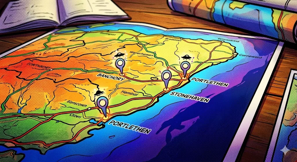
- Banchory, 21 December 1999: the MoD table lists “Banchory Aberdeenshire” and describes one circular object, white and very bright, moving downwards. [GOV.UK Assets]assets.publishing.service.gov.ukUK AssetsUK Assets For a modern reader, Banchory may look simply like Aberdeenshire. For a historic-county project, it needs closer handling because Banchory sits on the Deeside edge of the Kincardineshire story.
- Stonehaven, 19 January 2003: the MoD table lists “Stonehaven Grampian” and records three bright lights forming a triangle, hovering rather than moving. [GOV.UK Assets]assets.publishing.service.gov.ukOpen source on service.gov.uk. This is the strongest example of a Kincardineshire sighting hidden under a now-obsolete regional label.
- Portlethen, 28 February 2009: the MoD table lists “Portlethen Aberdeenshire” and describes a big yellow glow south of Aberdeen, about 2,500 feet high, which the witness did not think was aircraft landing lights. [GOV.UK Assets]assets.publishing.service.gov.ukufo report 2009ufo report 2009 Portlethen is now routinely framed through Aberdeenshire and Aberdeen commuter geography, but it is also within the Kincardine and Mearns local frame.
These examples do not create a dramatic Kincardineshire “flap”. They show something more modest but more reliable: local UFO evidence can disappear from view if the researcher searches only the historic county name. The opposite mistake is just as serious. A report from elsewhere in modern Aberdeenshire, or from the former Grampian region, should not automatically be pulled into Kincardineshire unless the town, parish or coordinates place it inside or very close to the historic county.

Why “Grampian” is especially easy to misread
“Grampian” is one of the most awkward labels for UFO research in north-east Scotland because it was a regional administrative term, not a historic county. It covered a much wider area than Kincardineshire. A Grampian-labelled UFO report could relate to Stonehaven and be directly relevant here, or it could point to Aberdeen, Banffshire, Moray or another part of the north-east beyond the Kincardineshire branch.
This is more than a pedantic mapping point. UFO records are often already thin: a time, a place, a colour, a shape and a short witness description. If the place label is also broad, the evidential value drops further. “Stonehaven Grampian” can be placed with reasonable confidence because the town anchors the report. “Grampian” alone would not be enough to count as Kincardineshire evidence without another locator.
The same caution applies to local media searches. A newspaper serving Aberdeen and the north-east may report a “north-east UFO” or “Grampian sighting” because that is how its readership understands the region. That may be useful for finding leads, but it is not enough for county attribution. A public-facing Kincardineshire UFO page should avoid making a sighting look more local than the source allows.
How to place sightings fairly
A fair Kincardineshire UFO record should work from the most precise location outward. The town or village matters first; the historic county comes next; modern council and old regional labels help explain the source but should not override the geography.
A practical rule is to classify each report in three layers:
- Reported label: preserve the wording used by the source, such as “Stonehaven Grampian” or “Portlethen Aberdeenshire”.
- Historic-county placement: decide whether the location belongs to historic Kincardineshire, sits on a boundary, or lies outside it.
- Interpretive caution: say what the report can and cannot support, especially when the entry is brief and no investigation file, photograph, radar data or witness interview is available.
This approach prevents two common distortions. It stops undercounting, where Kincardineshire looks empty because records were filed under Aberdeenshire or Grampian. It also stops overcounting, where every north-east Scotland UFO report is folded into Kincardineshire even when the place is plainly elsewhere.
The boundary rule is especially important near Aberdeen and the River Dee. Historic county borders, later city expansion and modern council geography do not always line up neatly. Kincardineshire sources note that parts of the City of Aberdeen extend south of the Dee into historic Kincardineshire territory, while modern local government has moved some areas into Aberdeen City administration. [Association of British Counties]abcounties.comAssociation of British CountiesKincardineshireKincardineshire, which has also been named “the Mearns”, is a triangular shire on the North… For UFO interpretation, this means an “Aberdeen” or “south of Aberdeen” report may need a precise locality before it can be confidently included.

What the boundary issue changes about the UFO story
The boundary issue does not make the Kincardineshire UFO record stronger in a sensational sense. It makes it clearer. The known official entries remain brief, low-detail reports of lights or bright objects. There is no public evidence in these entries of a recovered craft, a confirmed military interception, a radar-visual case or a solved extraordinary event. The MoD’s own published stance was that it looked for defence significance rather than trying to solve every sighting as an object-identification exercise. [The Black Vault]documents.theblackvault.comOpen source on theblackvault.com.
What changes is the reader’s understanding of why the record looks scattered. Kincardineshire is an old county name embedded within later Aberdeenshire, Grampian and Kincardine and Mearns labels. A single local sky can therefore appear under several archival headings. Stonehaven can be a Kincardineshire town, a Grampian UFO entry and a modern Aberdeenshire locality depending on which system is being used.
That also affects comparisons with neighbouring branches. A Kincardineshire page can naturally connect to wider Aberdeenshire, Aberdeen, Angus and north-east Scotland UFO material, but those links should be treated as neighbouring context rather than automatic inclusion. Aircraft routes, newspaper markets, police areas and witnesses’ descriptions cross county lines; the county index exists to keep the story legible, not to pretend the sky stops at the border.
A good county record keeps both names visible
The best presentation is not to choose between old and modern names, but to show both. A sighting can be written as “Stonehaven, historic Kincardineshire; recorded by the MoD as Grampian” or “Portlethen, within the Kincardine and Mearns/Aberdeenshire frame; relevant to the historic Kincardineshire branch”. That wording tells the reader why the report belongs here without silently rewriting the source.
For local UFO history, this is the difference between a clean map and a misleading one. Historic Kincardineshire gives the project its stable geographic anchor. Modern Aberdeenshire and former Grampian labels explain how records were filed. The sighting itself still has to stand on its own evidence: date, time, location, witness description, possible aircraft or astronomical explanations, and whether any later reporting strengthened or weakened the original claim.
Amazon book picks
Further Reading
Books and field guides related to Why Place Names Change the UFO Story. Use these as the next step if you want deeper reading beyond the article.
UFOs
Provides context for interpreting official records regardless of place-label changes.
Scotland, the Autobiography
Supports understanding of changing Scottish regional and historical identities.
UFOs: Generals, Pilots, and Government Officials Go on the Re...
Provides context for interpreting official records regardless of place-label changes.
The Demon-haunted World
Encourages careful handling of fragmented historical evidence.
eBay marketplace picks
Marketplace Samples
Example marketplace items related to this page. Use the search link to explore similar finds on eBay.


Endnotes
-
Source: GOV.UK
Title: ufo reports in the uk
Link: https://www.gov.uk/government/publications/ufo-reports-in-the-ukSource snippet
December 4, 2007 — 4 Dec 2007 — UFO reports 1997 to 2009 in the UK, showing dates and times, location and a brief description of the sigh...
Published: December 4, 2007
-
Source: Wikipedia
Link: https://en.wikipedia.org/wiki/Kincardineshire -
Source: commons.wikimedia.org
Title: Category:SVG maps of historic counties of the United Kingdom
Link: https://commons.wikimedia.org/wiki/Category%3ASVG_maps_of_historic_counties_of_the_United_Kingdom -
Source: commons.wikimedia.org
Link: https://commons.wikimedia.org/wiki/File%3ABritish_Isles_map_showing_UK%2C_Republic_of_Ireland%2C_and_historic_counties.svg -
Source: legislation.gov.uk
Link: https://www.legislation.gov.uk/ukpga/1973/65/enacted -
Source: legislation.gov.uk
Link: https://www.legislation.gov.uk/ukpga/1973/65/schedules/1995-10-30/data.xht?view=snippet&wrap=true -
Source: assets.publishing.service.gov.uk
Link: https://assets.publishing.service.gov.uk/media/5a75c656e5274a545822e1ea/UFOReports2003WholeoftheUK.pdf -
Source: assets.publishing.service.gov.uk
Title: UK Assets
Link: https://assets.publishing.service.gov.uk/media/5a79bcace5274a684690bbc2/UFOReport1999.pdf -
Source: assets.publishing.service.gov.uk
Title: ufo report 2009
Link: https://assets.publishing.service.gov.uk/media/5a7582c440f0b6397f35efcb/ufo_report_2009.pdf -
Source: aberdeenshire.gov.uk
Link: https://www.aberdeenshire.gov.uk/media/18325/kincardine-mearns-profile-2016.pdf -
Source: aberdeenshire.gov.uk
Link: https://www.aberdeenshire.gov.uk/media/4694/20150311kincardinemearnsprofile2015.pdf -
Source: publications.aberdeenshire.gov.uk
Title: locality profiles
Link: https://publications.aberdeenshire.gov.uk/locality-profiles -
Source: nationalarchives.gov.uk
Link: https://www.nationalarchives.gov.uk/explore-the-collection/explore-by-time-period/postwar/ufo-reports/ -
Source: nationalarchives.gov.uk
Link: https://www.nationalarchives.gov.uk/help-with-your-research/research-guides/ufos/ -
Source: upload.wikimedia.org
Title: Kincardineshire (IA kincardineshire00kinniala)
Link: https://upload.wikimedia.org/wikipedia/commons/2/26/Kincardineshire_%28IA_kincardineshire00kinniala%29.pdf -
Source: commons.wikimedia.org
Title: Category:SVG maps of historic counties in the United Kingdom
Link: https://commons.wikimedia.org/wiki/Category%3ASVG_maps_of_historic_counties_in_the_United_Kingdom -
Source: commons.wikimedia.org
Title: File:English counties 1851 with ridings.svg
Link: https://commons.wikimedia.org/wiki/File%3AEnglish_counties_1851_with_ridings.svg -
Source: commons.wikimedia.org
Title: File:English counties 1851 (numbered).svg
Link: https://commons.wikimedia.org/wiki/File%3AEnglish_counties_1851_%28numbered%29.svg -
Source: commons.wikimedia.org
Title: Category:Historic counties of the United Kingdom
Link: https://commons.wikimedia.org/wiki/Category%3AHistoric_counties_of_the_United_Kingdom -
Source: Wikipedia
Title: UFO sightings in the United Kingdom
Link: https://en.wikipedia.org/wiki/UFO_sightings_in_the_United_Kingdom -
Source: Wikipedia
Title: Historic counties of England
Link: https://en.wikipedia.org/wiki/Historic_counties_of_England -
Source: Wikipedia
Title: Local Government (Scotland) Act 1973
Link: https://en.wikipedia.org/wiki/Local_Government_%28Scotland%29_Act_1973 -
Source: Wikipedia
Title: File:Northern England Historic counties.svg
Link: https://en.wikipedia.org/wiki/File%3ANorthern_England-Historic_counties.svg -
Source: Wikipedia
Title: Local government areas of Scotland (1975–1996)
Link: https://en.wikipedia.org/wiki/Local_government_areas_of_Scotland_%281975%E2%80%931996%29 -
Source: legislation.gov.uk
Link: https://www.legislation.gov.uk/ukpga/1973/65 -
Source: archive.org
Link: https://archive.org/download/kincardineshire00kinnuoft/kincardineshire00kinnuoft.pdf -
Source: gov.scot
Title: www.gov.scot Local government
Link: https://www.gov.scot/policies/local-government/ -
Source: wikishire.co.uk
Link: https://wikishire.co.uk/wiki/KincardineshireSource snippet
Kincardineshire4 Nov 2016 — The County of Kincardine or The Mearns is a coastal shire at the edge of the Highlands. It lies on t...
-
Source: abcounties.com
Link: https://abcounties.com/counties/county-profiles/kincardineshire/Source snippet
Association of British CountiesKincardineshireKincardineshire, which has also been named “the Mearns”, is a triangular shire on the North...
-
Source: abcounties.com
Link: https://abcounties.com/introduction/Source snippet
Association of British CountiesAbout the CountiesJanuary 4, 2020 — There are 92 historic counties in the UK: 39 in England, 6 in Northern...
Published: January 4, 2020
-
Source: aberdeenshirestorage.blob.core.windows.net
Title: kincardine mearns area profile 2023
Link: https://aberdeenshirestorage.blob.core.windows.net/acblobstorage/657ef4bd-7437-4d3b-97e9-59f2efb81c41/kincardine–mearns-area-profile-2023.pdf -
Source: documents.theblackvault.com
Link: https://documents.theblackvault.com/documents/ufos/UK/defe-24-2038-1-1.pdf -
Source: aberdeenshirestorage.blob.core.windows.net
Title: aberdeenshire area profile data tables 2023
Link: https://aberdeenshirestorage.blob.core.windows.net/acblobstorage/3e55f4a9-19fe-47e4-9172-16d463537843/aberdeenshire-area-profile-data-tables-2023.pdf -
Source: wikishire.co.uk
Title: Great Britain and Ireland
Link: https://wikishire.co.uk/map/
Additional References
-
Source: planbee.com
Link: https://planbee.com/pages/counties-of-the-uk?srsltid=AfmBOop9efoHirkwez0l7qxTRmWWb3s1v7c1wT0RLkVTJBxX-39NKbBW -
Source: historiccountiestrust.co.uk
Link: https://historiccountiestrust.co.uk/descriptions -
Source: realcounties.com
Link: https://realcounties.com/wp-content/uploads/2023/10/historic_counties_standard.pdf -
Source: visionofbritain.org.uk
Link: https://www.visionofbritain.org.uk/place/17433 -
Source: facebook.com
Link: https://www.facebook.com/groups/3535660586462020/posts/24530581259876647/ -
Source: county-borders.co.uk
Link: https://www.county-borders.co.uk/ -
Source: facebook.com
Title: discover the definitive 2025 historic counties map of the uk ️printed on premium
Link: https://www.facebook.com/RealCounties/videos/discover-the-definitive-2025-historic-counties-map-of-the-uk-%EF%B8%8Fprinted-on-premium/1341246304166582/ -
Source: facebook.com
Title: today is 30 years since grampian regional council ceased to exist and aberdeen
Link: https://www.facebook.com/aberdeencityandshirearchives/posts/-today-is-30-years-since-grampian-regional-council-ceased-to-exist-and-aberdeen-/1419325623557067/ -
Source: ouraberdeenshire.org.uk
Title: kincardine and mearns communities and action plans
Link: https://www.ouraberdeenshire.org.uk/your-area/kincardine-and-mearns/kincardine-and-mearns-communities-and-action-plans/ -
Source: boundaries.scot
Title: Local government Scotland before 1975 1758892795
Link: https://www.boundaries.scot/wp-content/uploads/2025/09/Local_government_Scotland_before_1975_1758892795.pdf
Topic Tree